


CASE STUDY AREAS
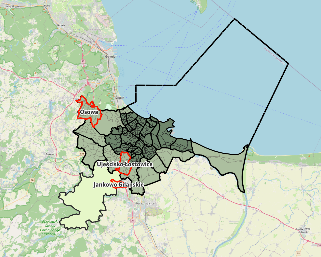
The case studies encompass three selected suburban areas in Gdańsk and its metropolitan region: Osowa, Ujeścisko–Łostowice, and Jankowo Gdańskie. These areas represent diverse spatial, functional, and demographic conditions characteristic of contemporary suburbanisation processes in Central and Eastern Europe. They were selected due to differences in their urban morphology, population density, and the structure of public spaces, enabling a comparative analysis of their use as components of the urban metabolism. The locations of the study areas are presented in Figure 1.
Osowa
Osowa is a suburban district located in the western part of Gdańsk. Its spatial structure has been partially shaped by the historical layout of a former village, resulting in a relatively well-defined local centre organised along the main streets. Among the analysed case study areas, Osowa is the most functionally developed and exhibits the characteristics of a relatively self-sufficient suburban district. It contains two primary schools, a post office, two churches, a healthcare centre, and a wide range of everyday services. Its public spaces include parks, pedestrian streets, recreational routes, and a skatepark, supporting both daily mobility and recreational activities.
Ujeścisko–Łostowice
Ujeścisko–Łostowice is a high-density suburban district located in the southern part of Gdańsk, characterised by rapid residential development dominated by large multi-family housing estates. Its spatial structure is strongly influenced by the main transport infrastructure, resulting in the fragmentation of neighbourhood units and limited continuity of pedestrian spaces. Public spaces are primarily integrated within residential estates or associated with green-blue infrastructure, such as stormwater retention ponds, rather than forming clearly defined urban centres. Consequently, the everyday use of public spaces is dispersed and functionally specialised.
Jankowo Gdańskie
Jankowo Gdańskie is a low-density suburban settlement located outside the administrative boundaries of Gdańsk. Its spatial structure is dispersed and retains a partly rural character, lacking a clearly defined centre and offering only a limited number of local public spaces.
The use of public spaces is primarily determined by the proximity of residential development and everyday neighbourhood-scale activities, representing an example of a low-intensity and strongly locally embedded suburban metabolism.
Comparison of the Case Study Areas – Spatial and Demographic Context
Although all of the analysed areas are suburban, they differ significantly in terms of population density, forming a clear gradient of suburban development ranging from dispersed, low-density settlements to high-density urbanised areas. These differences provide the context for interpreting the diverse patterns of public space use observed in the UAV study, including the intensity of use, diversity of activities, and temporal rhythms. The tables below present a comparative overview of the individual case study areas and the analysed public spaces. Further details are available in the following publication:
Mazurkiewicz, W., Borucka, J., Rubczak, A., & Wieczerzak, J. (2026). Integrating Space Syntax and Drone-Based Monitoring for City Metabolism Analysis in Suburban Public Spaces. Sustainability, 18, 6440. ARTYKUŁ
Table 1. Demographic characteristics of the suburban case study areas (data from September–October 2024) (Source: Mazurkiewicz et al., 2026)
|
Selected suburban area |
Population |
Area (ha) |
Gęstość zaludnienia (osoba/ha) |
|
Jankowo Gdańskie |
1,048 |
293 |
3,58 |
|
Gdańsk Osowa |
16,247 |
1,376 |
11,84 |
|
Gdańsk Ujeścisko–Łostowice |
24,307 |
786 |
30,93 |
For the purposes of the project, five public spaces were identified within the selected suburban areas as separate research units with coherent functional and spatial boundaries. These spaces represent diverse types of urban and suburban environments — ranging from pedestrian and recreational areas, through landscape-oriented spaces, to multifunctional service zones — enabling their comparative analysis in terms of everyday use and spatial organisation. Table 2 presents the characteristics of the analysed public spaces.
Table 2. Characteristics of the analysed public spaces (Source: Mazurkiewicz et al., 2026)
|
|
Public Space 1 |
Public S[ace 2 |
Public Space 3 |
Public Space 4 |
public Space 5 |
|
Case study area |
Gdańsk Osowa |
Gdańsk Osowa |
Jankowo Gdańskie |
Gdańsk Ujeścisko–Łostowice |
Gdańsk Ujeścisko–Łostowice |
|
Location within the city structure (inner / intermediate / peripheral zone) |
inner zone |
inner zone |
peripheral zone |
intermediate zone |
peripheral zonea |
|
Location within the district |
The historic center of Gdańsk Osowa |
The newer residential part of Gdańsk Osowa |
The central part of Jankowo Gdańskie |
Residential areas of Ujeściska–Łostowice |
Along the main access road in Ujeścisko-Łostowice |
|
Key characteristics |
Pedestrian-oriented service street / local center axis |
Recreational area |
Local neighborhood space |
Landscape space |
Multifunctional space by the main road (church + retail services) |
|
Additional features and functions |
Pedestrian street, local services, school |
Skatepark, playground, green space, proximity to the church |
Playground, outdoor gym |
Retention basin, walking paths, green areas, playground |
Church square, adjacent retail and service outlets |